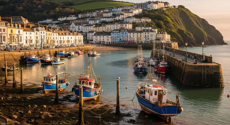
7 Best Walks in Dartmoor National Park | Complete Guide
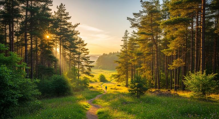
Mist rolls across granite tors at dawn. Wild ponies graze beside Bronze Age stone circles. The light has that particular quality that makes Dartmoor feel like stepping into another century entirely.
And here’s the thing: you can experience all of this without needing technical climbing skills, specialist equipment, or a week’s holiday. The 368 square miles of Dartmoor National Park reward both the casual weekend wanderer and the serious fell-bagger.
But standing in front of a map of Dartmoor, you face a familiar problem. Where do you actually start? The sheer scale creates choice paralysis.
You don’t want to drive two hours only to discover your chosen walk is either a disappointing muddy trudge or an unexpectedly technical scramble beyond your fitness level.
This guide cuts through that confusion. You’ll get seven tested walks spanning easy family rambles to challenging tor-baggers, each with specific distances, trailhead details, difficulty ratings, and what actually makes it worth your Saturday.
By the end, you’ll know exactly where to park, what to bring, and how to navigate safely on terrain that feels genuinely wild while remaining accessible.
Hiking Destinations In Dartmoor: What Makes These Walks Special

Dartmoor isn’t like other British moorland. It sits as a high plateau—around 1,500 feet at its centre—studded with granite outcrops called tors that jut from the landscape like ancient bones.
Around those tors, you’ll find open heather moorland, river valleys carved deep enough to feel like canyons, and pockets of dwarf oak woodland so atmospheric they seem transplanted from folklore.
What makes Dartmoor distinct is the “wild without wilderness” appeal. You get dramatic scenery and genuine solitude, but you’re not hiking into true remoteness. Most walks are within 5-10 miles of villages with pubs and shops. Mobile signal drops in patches, but you’re not days from help.
The landscape feels untamed because it genuinely is—Dartmoor has been common land for centuries, grazed by livestock and ponies rather than fenced and managed.
The landscape also carries visible history layered into every walk. Bronze Age settlements like Grimspound sit intact on the moor, stone circles mark ceremonial sites that predate Stonehenge, and the Victorian letterboxing tradition (a kind of outdoor scavenger hunt unique to Dartmoor) has left small stone boxes hidden along countless routes. You’re not just walking through scenery; you’re walking through time.
The seven walks here span difficulty from 2-mile family strolls to 8-mile full-day adventures, spread geographically across the moor so you can explore different character—high exposed tors, river valleys, ancient woodlands. Each offers something genuinely distinctive rather than just another generic moorland view.
Dartmoor National Park Walking Routes: The Complete List

1. Haytor and Hound Tor Circular (5.5 miles, Moderate)
Park at Haytor car park (postcode TQ13 9XT; £3 for four hours, coins only). The tor looms above immediately—granite stacked like a giant’s chess pieces. This is the walk most first-time Dartmoor visitors choose, and deservedly so.
The route climbs to Haytor’s summit (around 200m elevation gain total), offering 360-degree views that stretch to Exeter on clear days.
From there, you descend across open moorland to Hound Tor, where medieval village ruins sit among the boulders—actual stone foundations of houses abandoned in the 14th century.
The paths are clear and well-trodden. One steep section leads to Haytor itself, but it’s a genuine scramble rather than a technical climb—hands optional, fitness matters more than skill.
The moorland section between the two tors is boggy in places, so waterproof boots are essential even in summer. On days when wind is fierce or mist descends, this high moorland becomes serious terrain. Conversely, on a still morning with clear visibility, it’s genuinely magical.
Best for first-time Dartmoor visitors wanting the classic experience, photographers chasing light on granite, and anyone wanting proof that Dartmoor walks deliver on their atmospheric promise. Allow three hours for the walk itself, longer if you’re stopping for photos or exploring the Hound Tor ruins thoroughly.
2. Wistman’s Wood and Two Bridges (3 miles, Easy-Moderate)
Park near Two Bridges (the actual bridge where the East and West Dart rivers meet; postcode TQ13 7NP). This walk enters one of Britain’s last temperate rainforests—a dwarf oak woodland so gnarled and moss-covered it feels like stepping into a different climate entirely.
The trees are stunted by exposure and poor soil, but they’re genuinely ancient, their trunks twisted into shapes that make you understand why people once believed in forest spirits.
The route follows the river through the woodland, then returns along the open moorland above. It’s only three miles, but the terrain is boggy and rooty, so it takes longer than the distance suggests. Waterproof boots aren’t optional here—the ground is perpetually damp.
Midweek mornings in autumn offer the best combination of fewer crowds and dramatic light filtering through the trees. Summer weekends bring families; winter brings serious hikers seeking moody atmosphere.
Best for those seeking mystical woodland atmosphere without needing high fitness levels, photographers drawn to gnarled trees and dramatic light, and anyone wanting to experience one of England’s rarest ecosystems.
The walk rewards moving slowly and looking closely—moss-covered rocks, ferns unfurling in unlikely places, the particular sound of water in a woodland valley.
3. Burrator Reservoir Loop (3.5 miles, Easy)
Park at Norsworthy Bridge car park (postcode PL20 6SA; free parking). This is the walk you choose when you want Dartmoor scenery without moorland exposure or technical terrain.
The reservoir itself is Victorian engineering, built in 1898 to supply Plymouth with water, and it’s genuinely beautiful—the water reflects surrounding hills, and the path is well-surfaced and mostly flat.
Most of the route is buggy-friendly, making it genuinely accessible for families with young children or anyone managing mobility challenges.
The loop combines woodland sections with open water views. On one side, you walk through mixed woodland; on the other, the path runs closer to the water’s edge.
Wildlife spotting is reliable: ducks, herons, the occasional buzzard. The terrain is gentle enough that you can actually talk and look around rather than focusing on foot placement.
Weather matters less here because the woodland provides shelter, and the flat terrain means you won’t be exhausted if conditions turn grim.
Best for families with young children, beginner-friendly introduction to Dartmoor walking, older adults wanting scenery without serious physical challenge, and anyone recovering from injury. Spring (April-May) is particularly good here—bluebells in the woodland, ducks with ducklings on the water, fresh growth everywhere.
4. Yes Tor and High Willhays (6 miles, Challenging)
Park at Meldon Reservoir car park (postcode EX20 4PJ; free). This walk climbs Dartmoor’s two highest points—Yes Tor and High Willhays, both over 2,000 feet. It’s genuinely wild walking.
The moorland is exposed, navigation is more demanding, and weather can deteriorate rapidly from clear to dangerous in minutes.
The reward is the feeling of being on top of something substantial, with views across Devon that stretch to the coast on clear days.
Part of the route crosses Ministry of Defence ranges used for military training, and access is restricted on firing days. Check the Dartmoor National Park Authority website for current restrictions before setting out.The terrain is rough moorland with few obvious paths in places, so navigation skills and an OS map are non-negotiable.
The elevation gain is significant (around 400m), and wind exposure on the high ground is serious. In winter or poor visibility, this becomes a serious undertaking requiring competent navigation and good fitness.
Best for experienced walkers seeking Dartmoor’s most dramatic high-moor experience, summit-baggers wanting to tick off Dartmoor’s highest peaks, and anyone with solid navigation skills ready to step up from easier walks. Allow four to five hours including summit time.
Bring a map, compass, and weather-appropriate gear. This walk delivers genuine wildness and genuine achievement—but only attempt it if you have the skills and fitness to manage it safely.
5. Grimspound and Hookney Tor (4 miles, Moderate)
Park near Widecombe village (postcode TQ13 7TF; limited free parking near the green). Grimspound is the destination—a Bronze Age settlement dating to around 1500 BCE, with stone walls defining individual house plots arranged in a circle. Standing in the middle, you’re looking at 3,500 years of history preserved in moorland.
The site is genuinely evocative: you can see where families lived, how they organized their settlement, what kind of landscape they inhabited.
The route combines archaeological interest with genuine walking challenge. You climb from Widecombe across open moorland to reach Grimspound, then continue to Hookney Tor. The terrain is moorland with few obvious paths in places, so navigation requires attention.
A clear day is essential—in mist, the moorland becomes featureless and disorienting. The elevation gain is moderate (around 150m), but the distance and terrain take longer than flat mileage suggests.
Best for history enthusiasts wanting cultural landscape alongside natural beauty, intermediate walkers ready to navigate less obvious paths, and anyone seeking a quieter route than the famous Haytor circuit. This walk rewards slow movement and curiosity.
Bring your OS map, check the weather forecast carefully, and allow three to four hours. The combination of archaeology and moorland scenery makes this a genuinely distinctive Dartmoor experience.
6. Lydford Gorge (1.5–3 miles, Easy-Moderate)
Lydford Gorge is a National Trust property (admission £5.50 adults; postcode EX20 4BH). The gorge itself is a river canyon carved by the Lyd River through moorland rock, culminating in the White Lady Falls—a waterfall that’s genuinely dramatic, especially after heavy rain.
The walk is much shorter than the moorland routes listed above, but it packs scenery into compact distance. You can do a short 1.5-mile walk to the falls and back, or a longer 3-mile circuit exploring both ends of the gorge.
The path is well-maintained and managed by the National Trust, which means it’s safe and clear but less “wild” than unmaintained moorland routes.
However, the gorge itself is genuinely atmospheric—steep sides, river noise, particular light quality in a wooded valley. The path includes steep sections and steps that can be slippery when wet.
It’s not suitable for very young children or anyone with serious mobility limitations, despite being shorter than other walks.
The waterfall is most impressive in spring (April-May) when snowmelt feeds the river, and autumn (September-November) when the trees turn bronze and gold.
Best for dramatic scenery in compact distance, those wanting managed paths with genuine wild feel, families with older children, and anyone wanting a shorter walk that still delivers atmosphere. Weekday mornings are quieter than weekends. Allow 1.5 to 2 hours for the full circuit.
7. Believer and Lakehead Hill (4.5 miles, Moderate)
Park at Postbridge (the famous clapper bridge; postcode PL20 6TN; free parking). This walk starts at one of Dartmoor’s most iconic spots—a medieval stone bridge that’s genuinely beautiful—then ventures into quieter moorland.
The route passes stone rows and cairns (Bronze Age ceremonial sites), climbs to Lakehead Hill (modest elevation but good views), and descends through East Dart River valley. It’s a walk where you’ll spend hours seeing nobody, which appeals to people seeking solitude rather than popular paths.
Navigation skills matter here. The paths are less obvious than on busier routes, and the moorland can be featureless in poor visibility.
An OS map is absolutely essential—this isn’t a walk you can navigate by following other people’s footprints. The terrain is typical moorland: boggy in places, rough underfoot, exposed to weather.
The elevation gain is moderate (around 150m), but the distance and rough ground mean it takes longer than easier walks of similar mileage.
Best for intermediate walkers ready to step up navigation skills, those seeking quieter routes away from busy car parks, anyone interested in Bronze Age archaeology, and people who want to experience Dartmoor’s sense of solitude. This walk rewards patience and attention.
Allow three to four hours. Bring map, compass, and weather-appropriate gear. The quietness of the moorland and the historical sites make this a genuinely distinctive Dartmoor experience.
Essential Dartmoor National Park Hiking Map and Navigation Tips

Which Maps You Actually Need
Get the OS Explorer OL28 (Dartmoor) map. This isn’t optional for anything beyond the most obvious, heavily-walked routes. The map shows contour lines, moorland features, water sources, and terrain detail that your phone cannot replicate in real-time when you’re actually on the moor.
Digital options like the OS Maps app work well for offline use (download the relevant section before you lose signal), but carry the paper map as backup. Paper doesn’t run out of battery at 3 PM when you still have two miles to walk.
Dartmoor’s specific navigation challenges make good maps essential. Few waymarks exist on open moorland—you’re relying on contour lines, terrain recognition, and careful compass work. Paths can disappear in wet conditions where the ground becomes a uniform boggy mess.
A map teaches you to read the landscape rather than blindly following footprints, which becomes genuinely valuable when visibility drops or you take a wrong turn.
Reading Dartmoor’s Landscape
Understanding contour lines on tors saves you from nasty surprises. Tors look steeper on the ground than they appear on paper, and a “gentle slope” can actually be a rough scramble with loose rock.
Learn to recognize bogs and wet ground from map symbols—areas marked as marshy ground aren’t impassable, but they’ll be boggy underfoot and slow your pace significantly. Use tors as navigation features.
Distinctive tors like Haytor or High Willhays are visible from miles away and serve as reliable landmarks when visibility is reasonable.
River crossings are marked on maps, and understanding whether you’re crossing stepping stones, a ford, or a bridge matters for route planning.
Some crossings are only passable at certain water levels. After heavy rain, rivers that are normally easy wading become serious obstacles. Check weather forecasts not just for your walk day but for the previous days—heavy rain upstream affects water levels hours later.
When Phone Navigation Isn’t Enough
Mobile signal is patchy across much of Dartmoor. You’ll have coverage near villages and car parks, but venture onto open moorland and you’ll lose it.
Battery drain accelerates in cold and wet conditions—what shows as 80% battery in your car might be 20% after an hour of walking in winter wind. Relying solely on your phone for navigation is a recipe for getting lost with a dead phone and no map.
The paper backup isn’t nostalgia; it’s genuine safety. A map and compass work in any weather, never run out of battery, and teach you landscape-reading skills that make you a better navigator overall.
Carry both: use your phone for photos and checking your location when signal is available, but navigate using your map and compass.
If you’re unfamiliar with compass use, spend an hour practicing before you hit the moor—it’s genuinely straightforward, and the skill makes moorland navigation manageable rather than stressful.
Travel Guide For Dartmoor: Planning Your Walking Day

Getting to Dartmoor and Base Towns
Dartmoor is accessible from major cities: Exeter (30 minutes to northern edge), Plymouth (45 minutes to southern edge), Bristol (90 minutes). If you’re planning a full day of walking, factor in driving time.
Different walks suit different starting points. Haytor and Hound Tor are easier to reach from Exeter. Yes Tor and High Willhays are closer to the A30 corridor. Lydford Gorge is on the western edge.
Base villages offer different advantages. Princetown (central) has the High Moorland Visitor Centre and is genuinely remote-feeling, with limited facilities but good access to central moorland walks.
Widecombe is picturesque and popular, with a famous village green and reasonable services. Moretonhampstead has better facilities (shops, restaurants, accommodation) and sits on the eastern edge.
Chagford is charming and well-provisioned. Choose your base based on which walks appeal and what level of facilities you want after your walk.
Public transport to trailheads is limited. Buses serve villages but not most car parks. If you’re not driving, plan walks that start from village car parks (like Postbridge or Widecombe) rather than remote moorland car parks.
The realistic assessment: having a car makes Dartmoor walking genuinely easier. Without one, you’re restricted to village-based walks and need to plan accordingly.
Best Times of Year for Each Walk Type
Spring (April-May) brings waterfalls full from snowmelt, bluebells in woodlands, and lambing season (which means you’ll encounter livestock with young, requiring careful distance and respect).
Summer (June-August) offers the warmest weather and longest daylight, but car parks fill by mid-morning on sunny weekends.
Heather bloom arrives in late summer (August-September), turning the moorland purple and gold. Autumn (September-November) delivers dramatic light, fewer crowds after school holidays, and bracken turning bronze.
Winter (December-March) shows the starkest beauty—bare moorland, dramatic light, but serious weather and shortest days that limit walking distance.
Choose seasons based on walk difficulty. Easier walks like Burrator Reservoir work year-round because woodland provides shelter and the terrain is gentle.
Challenging moorland walks like Yes Tor and High Willhays require summer or early autumn conditions—winter exposure is genuinely serious.
Woodland walks like Wistman’s Wood are atmospheric in any season but most rewarding in autumn when light filters dramatically through trees, or spring when growth is fresh.
Facilities and Post-Walk Recovery
Not all walks have nearby pubs, so plan accordingly. Haytor is close to the Warren House Inn (a genuine moorland pub operating since the 1840s).
Widecombe has the Church House Inn. Postbridge has the Postbridge Inn. These are legitimately worth visiting—moorland pubs have character that suburban chains lack. Many are serious about food, not just drinks. Booking ahead on weekends is smart.
The High Moorland Visitor Centre at Princetown has a café and toilet facilities. Some car parks have basic facilities; many don’t.
Plan your water and food accordingly. Bring more water than you think you’ll need—moorland walking is dehydrating, and there are no shops or water fountains on the moor.
Stock up on supplies before heading to remote car parks. Supermarkets in Exeter, Plymouth, or the larger villages have everything you need.
Dartmoor National Park Walking: What to Pack and Wear

The Dartmoor-Specific Kit List
Footwear matters more than on easier terrain. Proper walking boots with ankle support beat trail runners except in high summer drought conditions.
Boots keep your feet dry, provide ankle stability on rough moorland, and grip better on wet rock. Waterproof boots are essential—you’ll encounter boggy ground even on walks that don’t specifically mention it. Break boots in before you hit the moor; blisters on day one ruin the whole walk.
Layering for changeable weather is non-negotiable. Dartmoor genuinely delivers “four seasons in one walk”—you’ll start in sunshine and end in rain and wind, or vice versa.
Base layer (merino wool or synthetic, not cotton), mid-layer insulation (fleece), and waterproof outer shell are standard. Waterproofs that actually work matter—not just shower-proof jackets, but genuinely waterproof shells with taped seams.
Pack more layers than you think you’ll need. The cost of carrying extra weight is vastly less than the misery of being cold and wet on exposed moorland.
Navigation gear: map, compass, and a charged phone as backup. Emergency basics include a whistle (carries further than shouting if you need help), a torch (even summer walks can extend into dusk), basic first aid (blister treatment is genuinely valuable), and emergency food (energy bars, nuts, dried fruit—something that doesn’t require water or cooking). Bring more water than you plan to drink. A water bottle or hydration pack is essential.
Common Packing Mistakes
Underestimating how cold exposed tors get is the classic error. Even in June, wind on high ground can be genuinely bitter. Bring that extra fleece layer.
Insufficient water is another common mistake—you’ll drink more than you expect, especially if the weather is warm or windy.
Cotton clothing stays wet and dangerous in cool conditions; synthetic and wool dry faster and insulate better when wet. Relying on phone battery for everything leaves you stranded when battery dies at 2 PM with two miles still to walk.
Under-packing in general is the pattern. You’re not hiking an established trail with facilities. You’re on moorland where weather changes rapidly and help isn’t nearby.
Pack heavier than you think you need. The extra weight is genuinely less burdensome than being genuinely cold, hungry, or lost with a dead phone.
Seasonal Adjustments
Summer additions include serious sun protection—moorland exposure is surprising, and reflection off granite intensifies UV. Insect repellent helps in boggy areas where midges congregate.
Winter essentials include a hat (you lose enormous amounts of heat through your head), gloves, an extra insulation layer, and a head torch.
Winter days end early; a head torch lets you continue safely if you’re still out at dusk. Check sunrise and sunset times before you leave, and plan walks that finish before dark with a comfortable buffer.
Dartmoor Hiking Routes: Safety and Responsible Walking

Dartmoor’s Specific Hazards
Sudden weather changes are genuine. Mist descends rapidly—visibility can drop from miles to 50 meters in minutes. Temperature drops noticeably with elevation and wind. Bogs and mires are navigable if you know what you’re doing but genuinely dangerous if you panic.
Identify soft ground visually (it looks different—shinier, more uniform, less vegetated) and test ground with a stick before committing weight.
If you’re sinking, don’t panic; step back calmly and find firmer ground. Bogs are rarely truly impassable if you move carefully.
Ministry of Defence firing ranges occupy sections of Dartmoor. Check access restrictions before you leave home—the Dartmoor National Park Authority website lists current schedules.
Boundary markers are visible on the ground. Don’t ignore them; access is genuinely restricted on firing days for safety. Livestock (cattle, ponies, sheep) graze freely on Dartmoor.
Maintain safe distance, especially from animals with calves or lambs. Dogs should be under control. Adders (Britain’s only venomous snake) live on Dartmoor, but actual risk is tiny—they’re shy and bite only when stepped on or provoked. Wear boots and make noise as you walk; adders will move away.
Leave No Trace on the Moor
Dartmoor’s landscape is genuinely fragile. Thin soils, archaeological sensitivity, and erosion on popular paths all require care. Stick to established paths where they exist.
On open moorland where paths aren’t obvious, spread out rather than following single-file lines that create erosion channels.
Wild camping is allowed in most areas with restrictions—camp away from water sources, use no-trace principles, leave no evidence of your presence.
Litter and dog waste in remote areas don’t break down quickly in moorland conditions; pack everything out, including dog waste.
When to Turn Back
Weather decision-making is crucial. If visibility drops below 50 meters on open moorland, navigation becomes genuinely difficult unless you’re highly skilled.
Turn back. Recognize when you’re off-route early—if something feels wrong, check your map immediately rather than hoping it corrects itself.
Time management matters enormously, especially in winter. Allow enough daylight buffer that you finish with comfortable light remaining. Don’t push for “just one more mile” when it means finishing in darkness.
Emergency contacts: Dartmoor Search and Rescue operates across the moor. Call 999 and ask for police, who coordinate rescue. Have a charged phone (even if signal is patchy, emergency calls often get through).
Leave a rough itinerary with someone at home—tell them which walk you’re doing, expected return time, and what to do if you’re late. These simple steps create a safety net if something goes wrong.
CONCLUSION: Discover Your Perfect Dartmoor Walk

You now have seven tested Dartmoor walking routes spanning from gentle Burrator lakeside strolls to challenging Yes Tor summit pushes.
The key is matching walk to conditions and your honest fitness level. A moderate walk in poor visibility is harder than a challenging walk in clear weather.
A 3-mile walk at high altitude is more demanding than a 5-mile walk on flat terrain. Know yourself, check the forecast, and choose accordingly.
What makes Dartmoor worth the drive—what brings people back season after season—is that combination of accessible wildness, layered history, and landscapes that feel genuinely untamed while remaining navigable.
You get real moorland atmosphere without needing mountaineering skills. You encounter Bronze Age archaeology without specialist knowledge. You experience weather and exposure without technical climbing. That particular balance is rare.
Here’s your next step: Choose one walk based on current fitness and this week’s weather forecast. Download or purchase OS Explorer OL28. If you’re walking near Ministry of Defence firing ranges, check access schedules. Pack for worse weather than predicted.
Allow more time than mileage suggests—Dartmoor’s terrain and inevitable photo stops always take longer than flat calculations.
Start with one of the moderate routes like Haytor or Grimspound to get a feel for Dartmoor’s character, then explore deeper. This is a landscape that reveals itself slowly, rewarding repeat visits across seasons. Your first walk is just the beginning.