Italian Dolomites Hiking Safety Guide
Just sit back and imagine yourself standing at the edge of a scenic Alpine meadow, jagged limestone peaks piercing the sky above you, when suddenly the weather shifts. Dark clouds roll in faster than you expected. Do you know what to do?
I learned this lesson the hard way on my first Dolomites trek. I’d underestimated how quickly conditions change at altitude, and suddenly I was scrambling down scree in a thunderstorm, questioning every life choice that led me to that exposed ridge. That experience taught me something crucial: the Dolomites are breathtaking, but they demand respect.
Here’s what you’ll learn in this guide—knowledge I wish I’d had before that first trip:
– Essential safety protocols specific to the Dolomites terrain – Gear that could save your life (and what you can skip) – How to read weather patterns in the Alps – Navigation tips for hiking without a guide – Emergency procedures and when to call for help
The good news? With proper preparation, hiking the Dolomites is absolutely achievable for beginners and families. You don’t need to be an elite mountaineer. You just need to understand what makes these mountains different and plan accordingly.
Understanding the Dolomites: What Makes These Mountains Different

Unique Geology and Terrain Challenges
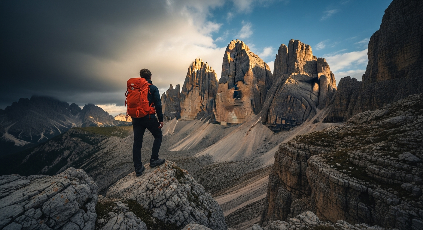
The Dolomites aren’t just another mountain range—they’re geological marvels with their own set of rules. These peaks consist primarily of dolomite rock, a distinctive limestone that creates those iconic vertical towers and jagged spires you’ve seen in photos. Beautiful? Absolutely. But this geology creates specific challenges you won’t find in other mountain ranges.
The limestone composition means you’ll encounter loose scree more often than you expect. Unlike the solid granite of many Alpine regions, dolomite crumbles and shifts underfoot.
I’ve watched experienced hikers stumble on what looked like stable ground because they didn’t adjust their technique. On scree fields, you need to step deliberately, test your footing, and accept that you’ll slide a bit on descents—it’s normal, not a sign you’re doing something wrong.
Elevation changes happen suddenly here. You’ll climb from 1,500 meters to over 3,000 meters in a single day hike. That’s significant altitude gain, and your body notices. Many peaks exceed 3,000 meters, with Marmolada topping out at 3,343 meters. The altitude alone demands acclimatization and respect.
The Alpine Climate: Beautiful but Unpredictable
The Dolomites have a personality disorder when it comes to weather. You can start your hike under brilliant sunshine and be dodging lightning strikes by afternoon. This isn’t an exaggeration—it’s the standard pattern during summer months.
The region experiences dramatic microclimate variations. A valley can be warm and calm while the ridge above is being hammered by wind and rain. I’ve stood on Seceda in perfect conditions while watching storm clouds dump rain on the valley I’d just left. This happens because the mountains create their own weather systems, with air masses colliding and creating rapid changes.
June through September is prime hiking season, but each month brings unique challenges. June often has lingering snow on high passes and trails might not be fully cleared. July and August offer the most stable weather but also afternoon thunderstorms—plan to summit by noon and be descending by 2 PM. September brings stunning fall colors and fewer crowds, but days are shorter and early snow can surprise you.
The afternoon thunderstorm pattern is so predictable that locals set their watches by it. Warm morning air rises, hits cooler air aloft, and by early afternoon, you’ve got towering cumulonimbus clouds dropping lightning on exposed ridges. This isn’t a “might happen” situation—it’s a “when, not if” reality you must plan around.
The Cultural Context: German-Italian Alpine Region
The Dolomites straddle cultures, sitting in the historically German-speaking South Tyrol region of Italy. This bilingual reality actually enhances your safety. Trail signs appear in both German and Italian, and many locals speak both languages plus English. When you need help or directions, you’ve got multiple linguistic options.
The rifugio system is your safety net. These mountain huts dot the landscape, offering food, accommodation, and crucially—refuge during emergencies. Unlike backcountry huts in other ranges, rifugios are staffed and welcoming. The mountain rescue culture here is deeply ingrained. Call 112 for emergencies, and the highly trained Alpine rescue teams (often volunteers) will respond. But here’s the thing: because rescue is so professional, some hikers get careless. Don’t be that person who assumes rescue is easy—it’s dangerous for the rescuers and expensive for you.
Essential Pre-Trip Planning for a Safe Dolomites Adventure

Choosing the Right Trail for Your Skill Level
The Dolomites use the CAI (Club Alpino Italiano) trail classification system, and understanding it could save your trip—or your life. Here’s what the ratings actually mean:
T (Turistico): Tourist trails on clear paths with minimal elevation gain. Think well-maintained paths through valleys and forests. Perfect for families and beginners.
E (Escursionistico): Hiking trails requiring basic fitness and proper footwear. You’ll encounter steeper sections, rougher terrain, and longer distances. This is where most day hikers should start.
EE (Escursionisti Esperti): Expert hiking trails with exposed sections, cable assists, and significant elevation gain. You need proper boots, navigation skills, and comfort with exposure.
EEA (Escursionisti Esperti con Attrezzatura): Expert trails requiring equipment like via ferrata sets, helmets, and sometimes climbing gear.
Here’s what most guidebooks won’t tell you: popular doesn’t mean easy. The Tre Cime di Lavaredo circuit is incredibly popular and looks straightforward in photos, but sections involve steep, rocky terrain that surprises unprepared hikers. I’ve seen people in running shoes struggling on scree fields, miserable and unsafe.
Assess your fitness honestly. Can you hike uphill for two hours without stopping? Do your knees handle descents well? Have you hiked at altitude before? If you’re coming from sea level and planning a 2,000-meter elevation gain hike on day one, you’re setting yourself up for a bad time.
Start with research on specific platforms like Outdooractive or Komoot, which provide detailed trail information including actual user experiences. Local tourism offices (APT offices) offer free maps and current trail conditions—use them.
Weather Research and Seasonal Timing
You need reliable weather forecasts, not the generic app on your phone. Mountain-Forecast.com provides altitude-specific forecasts that actually account for conditions at 2,500 meters versus valley level. The difference matters enormously.
Check weather forecasts obsessively in the days before your hike. Look for multi-day trends, not just tomorrow’s prediction. A stable high-pressure system gives you confidence. Unstable conditions with afternoon thunderstorms mean you adjust your plans—start earlier, choose shorter routes, or have bail-out options ready.
Even in peak summer (July-August), conditions can turn dangerous. I’ve hiked in June and encountered waist-deep snow on north-facing slopes. In September, I’ve been caught in early-season snowstorms that weren’t predicted. Always check current conditions through rifugios or local guides, not just forecasts.
Route Planning and Time Management
Start early. I mean really early—6 AM or earlier for longer hikes. This isn’t about beating crowds (though that’s nice). It’s about being off exposed ridges before afternoon thunderstorms roll in. The golden rule: summit by noon, be descending by 2 PM.
Calculating hiking time in the Dolomites requires more than measuring distance. Use Naismith’s Rule as a baseline: allow one hour for every 5 kilometers of distance, plus 30 minutes for every 300 meters of elevation gain. Then add 25% buffer time for the Dolomites specifically, because rocky terrain slows you down more than you expect.
Plan escape routes before you start. Where can you bail out if weather turns bad or someone gets injured? Which rifugios lie along your route? I mark these on my map before every hike—it takes five minutes and provides crucial options if things go sideways.
Share your itinerary with someone. Tell your accommodation host, a rifugio keeper, or someone back home. Include your planned route, expected return time, and emergency contact numbers. This seems paranoid until you need it.
Physical Preparation
You can’t fake fitness in the mountains. The Dolomites will expose your weaknesses quickly. I recommend at least six weeks of specific training before your trip: hill repeats, stair climbing, and loaded hiking with your actual pack.
Leg strength matters more than cardiovascular fitness. Descending 1,500 meters on loose scree destroys your quads if they’re not prepared. Squats, lunges, and step-downs build the eccentric strength you need.
Altitude acclimatization requires time. If possible, spend your first day or two at moderate elevation (1,500-2,000 meters) before attempting higher peaks. Sleep at lower elevations even if you hike high during the day—your body recovers better.
Practice hikes with your actual gear reveal problems before they become emergencies. Break in those boots. Test your pack’s weight. Learn whether that rain jacket actually keeps you dry. Better to discover issues on a local trail than at 2,800 meters in a storm.
The Ultimate Dolomites Hiking Gear Checklist

Footwear: Your Most Important Decision
Proper hiking boots are non-negotiable in the Dolomites. I’ve seen too many people suffering in trail runners or casual shoes, slipping on scree and nursing twisted ankles. The rocky, uneven terrain demands ankle support and aggressive tread.
Look for boots with stiff midsoles that support your feet on rocky terrain. The Dolomites aren’t soft forest trails—you’re stepping on sharp rocks constantly. Vibram soles provide excellent grip on both wet rock and scree.
Break in your boots before your trip. This isn’t optional advice—it’s mandatory. Wear them on multiple training hikes, including downhill sections. Blisters at altitude, miles from anywhere, are miserable and potentially dangerous. I learned this the hard way with new boots on day two of a trek. The resulting blisters nearly ended my trip.
Gaiters keep scree and small rocks out of your boots. They seem unnecessary until you’re shaking pebbles out of your boots every thirty minutes. Low-cut gaiters work fine for most trails; save the high ones for snow conditions.
Pack a complete blister kit: moleskin, blister bandages, athletic tape, and small scissors. Treat hot spots immediately, before they become full blisters.
Clothing Layers for Alpine Conditions
The three-layer system isn’t fashion advice—it’s survival strategy. Base layer, insulation layer, and shell layer give you flexibility for rapidly changing conditions.
Your base layer should be merino wool or synthetic fabric that wicks moisture. Cotton kills in the mountains—it holds moisture, steals your body heat, and dries slowly. I don’t care how comfortable that cotton t-shirt feels at the trailhead; leave it behind.
Mid-layer insulation (fleece or lightweight down) provides warmth during breaks and cold mornings. Even in August, early starts can be chilly, and temperatures drop quickly once you’re off the valley floor.
Your shell layer needs to be truly waterproof, not water-resistant. Look for jackets with sealed seams and hoods that fit over a helmet if you’re doing via ferratas. I’ve tested this in Dolomites thunderstorms—cheap rain jackets fail spectacularly.
Sun protection clothing matters at altitude. UV exposure increases significantly above 2,000 meters. Long-sleeve shirts, wide-brimmed hats, and neck buffs protect exposed skin. I’ve watched people burn badly on cloudy days because they underestimated high-altitude UV.
Gloves seem excessive for summer hiking until you’re gripping steel cables on a via ferrata or scrambling over cold morning rocks. Lightweight gloves for via ferratas (3/4-finger leather gloves work best) and warmer gloves for cold conditions earn their weight.
Navigation and Communication Equipment
Detailed topographic maps on paper are your backup when technology fails. The Tabacco maps (1:25,000 scale) are the gold standard for the Dolomites, showing trails, rifugios, and terrain features accurately.
GPS devices and smartphone apps provide excellent navigation—but only with offline maps downloaded before you lose signal. Gaia GPS and Maps.me both work well in the Dolomites. I use my phone as primary navigation and carry a GPS device as backup.
A compass and basic orienteering skills matter when fog rolls in or you lose the trail. You don’t need advanced navigation skills, but knowing how to take a bearing and orient your map is essential.
Portable chargers keep your phone alive for photos, navigation, and emergencies. I carry a 10,000 mAh battery pack that recharges my phone three times—overkill for day hikes, essential for multi-day treks.
A whistle and headlamp belong in every pack, even for day hikes. The international distress signal is six whistle blasts per minute. A headlamp gets you down safely if you’re delayed—which happens more often than you’d think.
Safety and Emergency Gear
Your first aid kit should address common hiking injuries: blisters, cuts, sprains, and minor burns. Include elastic bandages, athletic tape, pain relievers, antihistamines, and any personal medications.
An emergency shelter or bivy sack weighs almost nothing and provides crucial protection if you’re stuck overnight. I carry a SOL Emergency Bivy—it’s saved me once and provided peace of mind countless times.
Fire starter and emergency whistle are lightweight insurance. The whistle signals for help; the fire starter could save your life in a bad situation.
A multi-tool or knife handles gear repairs, first aid tasks, and countless small problems. Don’t overpack here—a basic Leatherman or Swiss Army knife suffices.
Sunscreen (SPF 50+) and lip balm with SPF prevent painful burns. Apply sunscreen every two hours, even on cloudy days. High-altitude sunburn is no joke.
Sunglasses should provide UV protection and side shields for high routes. Glacier glasses aren’t overkill on snowfields or highly reflective limestone.
Hydration and Nutrition
Carry 1.5 to 2 liters of water minimum per person for day hikes. More for longer routes or hot weather. Dehydration at altitude impairs judgment and physical performance.
Water purification tablets or a filter allow you to refill from streams—but not all streams in the Dolomites are safe. Livestock grazing means potential contamination. I purify all stream water, even if it looks pristine.
High-energy snacks keep you fueled: nuts, energy bars, dried fruit, and chocolate. I eat small amounts every hour rather than waiting until I’m hungry. Your body burns serious calories at altitude.
Electrolyte supplements prevent cramping and headaches during long hikes. I add electrolyte tablets to my water, especially on hot days.
Plan whether you’re packing lunch or stopping at rifugios. Rifugio meals are delicious and convenient, but they add time to your day. For longer hikes where time matters, pack your own food.
Via Ferrata Specific Equipment
Via ferratas require specialized gear—don’t attempt them without proper equipment.
A helmet is mandatory, protecting you from rockfall and your own head during falls. Any climbing helmet works; I prefer lightweight models for all-day comfort.
Your harness and via ferrata set must include a shock absorber that limits force in a fall. Modern via ferrata sets use Y-shaped lanyards with two carabiners, allowing you to stay clipped in while moving past anchors.
Gloves protect your hands on steel cables and rungs. Leather 3/4-finger gloves provide dexterity while protecting your palms. Full-finger gloves work but reduce feel.
Renting versus buying depends on how much via ferrata you’ll do. For one or two routes, rent from local shops (€15-25 per day). For a full trip, buying your own kit makes sense (€80-150 for quality gear).
Do a safety check before starting: inspect your equipment, practice clipping and unclipping, and verify your harness is properly fitted. Most via ferrata accidents happen from user error, not equipment failure.
On-Trail Safety Protocols: Staying Safe While You Explore

Weather Awareness Throughout Your Hike
Reading weather while hiking is a survival skill. Watch cloud formations constantly. Towering cumulus clouds building vertically signal potential thunderstorms. Dark bases and rapid growth mean storms are developing.
The afternoon thunderstorm rule is simple: be off exposed peaks and ridges by 2 PM. I’ve violated this rule exactly once and spent a terrifying hour huddled below a ridgeline while lightning struck nearby peaks. Never again.
If caught in a thunderstorm, get off ridges and peaks immediately. Avoid isolated trees and metal cables. Crouch low on insulating material (your pack, sleeping pad) with feet together. Don’t lie flat—minimize your contact with the ground.
Lightning safety positions feel awkward, but they work. Group members should spread out 15-20 meters apart to avoid multiple casualties from ground current.
Know when to turn back. This is where ego kills people. If weather looks threatening, if you’re behind schedule, if someone is struggling—turn around. The mountain will still be there tomorrow.
Navigation Best Practices
CAI trail markers (red-white-red painted bands) mark official trails throughout the Dolomites. They’re generally reliable, but they can fade or be obscured by snow. Never rely solely on markers—use your map.
If you lose the trail, stop immediately. Don’t wander hoping to find it. Check your map and GPS, identify your last known position, and backtrack if necessary. Most people who get seriously lost keep moving forward when they should stop and think.
Regular position checks keep you found. Every 20-30 minutes, confirm your location on the map. Note landmarks, check your progress, and verify you’re still on route.
Trust your map over your instinct. Humans are terrible at judging distance and direction in mountains. If your gut says go left but your map says right, follow the map.
Group hiking protocols matter. Stay within sight and sound of each other. The strongest hiker doesn’t charge ahead—they match the group’s pace. Designate a sweep person to ensure no one falls behind.
Pace and Energy Management
The “conversational pace” rule prevents overexertion: if you can’t hold a conversation while hiking, you’re going too hard. Slow down. Altitude and elevation gain demand a sustainable pace.
Take regular breaks—ten minutes every hour works well. Remove your pack, hydrate, eat a snack, and let your heart rate recover. These breaks prevent exhaustion and allow you to enjoy the scenery.
Altitude sickness symptoms include headache, nausea, dizziness, and unusual fatigue. If someone shows these signs, they need to descend. Don’t wait hoping they’ll improve—altitude sickness gets worse, not better.
Descending safely requires focus. Most hiking accidents happen on the way down when you’re tired and your attention wanders.